Paul Treutler p.91/92
Content
Pictures
Annotations
Text of Treutler
---
page +
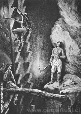
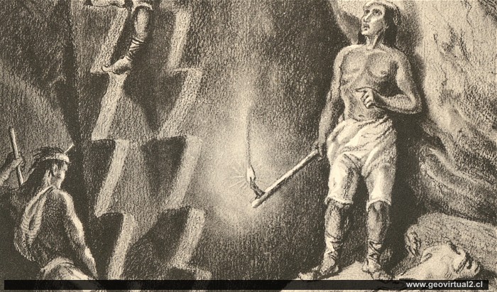
This picture, taken from the book of Treutler (15 years in South America) is a slightly modified copy of L. SIMONIN (1867)"La vie Souterraine Du Les Mines et Les Mineurs". see comparison with SIMONIN: see
Mining around 1852 was carried out with quite simple
methods. The pits followed mostly narrow veins with very high metal
content for today's standards. Unfortunately, the vein deposits were
very narrow (partly less than 1 metre), which led to a rapid deepening
of the mines. However, the ore content often decreased rapidly towards
depth. The length of the deposits was limited by geological conditions,
or other owners were simply active there.
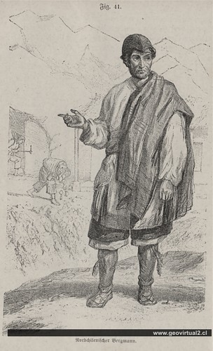
From: Ochsenius: Miner of northern Chile
Gilliss (1849 to 1855) also describes the working conditions in the mines - but in Chañarcillo (see here).
Other resources:
See also the description of the work of the apires and barreteros in the
mines of Chañarcillo.
more information of the Salvadora mine
Literature: Historic mining at Atacama
Extracts
Sections from Treutler 15 years in South America: Description of
a visit to the Salvadora Mine in Tres Puntas (Atacama, Chile):
The text refers to the years 1851 to 1856, but it should be
mentioned that
Paul Treutler's descriptions are not always authentic.
P. Treutler on his visit to the mine "Salvadora" (Tres Puntas):
(Hauer: Hewer, pickman (Schlepper: Barrow-man)
"To get to know the inside of the pit, I went down into the pit with
the steward at the entrance ramp. It was zigzagged and about 350 feet
(=108 m) deep. The richest limestone pathway was 4 1/2 feet (=1.40m)
thick, running from north to south, at a difference of 15°, and often in
this thickness consisted of almost pure silver. I saw blocks of them
lying on the ground, weighing in at 6 Ztr. (=300 Kg) and which were cut
with the axe in order to get them out. The lighting was provided by
tallow candles; each miner brought one of them to the top of his cane.
Everyone worked almost naked.
Not only could I admire the great power and muscle strength of the
miners, which often led 25 to 30 strokes in a row without resting, with
a 25 pound (12.5 kg) hammer. No less than the pickmen the barrow-men
attracted my attention, who with a leather bag, in which they carried 1
1/2 hundred kilograms (75 kg) of ore, often climbed 900 feet (279 m)
quite steeply singing up and in 24 hours this tour on twelve times.
As with the heels, the arm muscles, the calves were herculean. The
working time was not in specific hours, but alternated between the
pickmen and the barrow-men. After the first one had done his work, which
consisted of drilling and blasting, he stepped down and left the working
to the barrow-men, who brought the blown up ores and rocks to the
surface, and when the place had been cleared, the pickmen, began his
activity again. So this was an uninterrupted, day and night, week after
week during work. The construction of the mine was very simple and
appropriate to the conditions; it was completely dry, had no trunk of
wood needed and had good air. The tracks were 6 feet (1.86m) high and 5
feet (1.55 m) wide.
Up to now, all ore was put in bags on the back of the barrow-men to go
way out to surface (#1); however, a vertical shaft had already been sunk
to the deepest level and a horse-capstan(#2) had to be erected in order
to extract the ores from it".
#1) More horizontal, more or less passable tunnels entrances and exits.
#2) Horse-capstan: Device for extracting ores from the shaft with
horsepower. In most cases it was a turnstile with two horses, which were
used to pull up a rope or a steel chain with a transport box. (For
example, horse-capstan in Johanngeorgenstadt.
Los textos originales fueron digitalizados, transformados a ASCII redactados y traducidos por Dr. Wolfgang Griem.
This picture, taken from the book of Treutler (15 years in South
America) is a slightly modified copy of L. SIMONIN (1867)"La vie
Souterraine Du Les Mines et Les Mineurs". see comparison with SIMONIN
Mining Atacama
Journey to Atacama
List
of mining districts Atacama
History of mining 1830-1920
Chañarcillo
Tres Puntas
Ruins of village
Cemetery of Tres Puntas
Buena Esperanza
mine,
Cobriza
Cronología de Tres Puntas
Treutler:
Living in Tres Puntas
Treutler:
Pub at Tres Puntas
►
Treutler: Interior Salvadora
Treutler: Situación laboral
Treutler: Minería Tres Puntas
Treutler: Terremoto en Tres Puntas
Treutler: Accidente en Tres Puntas
San Román:
Geol. of Tres Puntas
Carta minero de Cornwall
Philippi at Tres Puntas
Philippi: Descripción Tres Puntas
Philippi: Historia Tres Puntas
Cartas sector Tres Puntas
Listado minas de Tres Puntas
Estadísticas de Tres Puntas
Cerro Blanco
district
Lomas Bayas
More mining districts ....
Tres Puntas content
Village of Tres Puntas
Cemetery of Tres Puntas
Buena Esperanza
mine
Mina Cobriza
Cronología de Tres Puntas
Historical records
Treutler, living in Tres Puntas
Treutler:
Pub at Tres Puntas
Treutler - Mina en Tres Puntas
Treutler - los mineros, Tres Puntas
Treutler: Minería en Tres Puntas
Terremoto en Tres Puntas (Treutler)
Treutler accidente en Tres Puntas
Carta de un minero de Cornwall
Philippi en Tres Puntas (1856)
Philippi: Descripción Tres Puntas
Philippi: Historia Tres Puntas
Carta del sector Tres Puntas
Listado de las minas de Tres Puntas
Estadísticas de Tres Puntas
Mining
at Atacama
Mining
in the years 1830-1920
List of minig districts Atacama
Chañarcillo
Tres Puntas
Carrizal Alto
Cerro Blanco
district
Lomas Bayas
Cabeza de Vaca
Paul Treutler (1851)
Intro Treutler en Atacama
Paul Treutler en Copiapó
Paul Treutler en Caldera
viaje en Ferrocarril por P. Treutler
Treutler: Accidente ferroviario 1853
Treutler en Tres Puntas
en Salvadora (Tres Puntas)
accidente en Tres Puntas
carta de Atacama
Terremotos (general)
Terremoto en Tres Puntas, Atacama
TREUTLER - SIMONIN, comparación
Paul Treutler
Total comparison
Visitors to Atacama
List of Visitors
R.A. Philippi en Atacama
Paul Treutler en Atacama
Charles Darwin, Atacama (1835)
Ignacio Domeyko y Copiapó
Kunz en Copiapó
Hugo Kunz en Chañarcillo
Gilliss Mineros en Chañarcillo