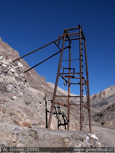
Photo: Shaft frame in the Cerro Blanco mine sector, Atacama desert,
Chile. W. Griem (2005 -
Kodak6282)
Large photo
Photo Information: Camera Kodak DX6490: [100_6282.jpg]
Focal Length: 6,3mm (=38/35mm) | Time: 1:350
F: f/8 | Original size: 2304 x 1728 | Date: 2005/07/22/16:19 hrs.
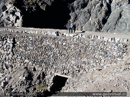
Photo: Road to the town of Cerro Blanco, Atacama desert, Chile. W. Griem (2005 -
Kodak6292)
large
Photo Information: Camera Kodak DX6490: [100_6292.jpg]
Focal Length: 6,3mm (=38/35mm) | Time: 1:180
F: f/6.3 | Original size: 2304 x 1728 | Date: 2005/07/22/16:27 hrs.
Mines of Cerro Blanco: p.1 | p.2
The mining sector of Cerro Blanco still shows in a
impressive way the mining situation of past eras. Up to the present day,
constructions, foundations, ruins, slag accumulations and old roads are
surprising due to their immense dimensions and extensions.
The access roads were of high quality (they used to be, because today
they may have been cut by alluvial deposits or are eroded deeply),
especially they were wide and of little slope and always inclined from
the mine to the smelter. In 1869 the district produced 1,462,716
kilograms of fine copper and 652,489 kilograms of fine silver. It was
more than the district of Puquios, but compared to today it is not even
4% of a mine like Punta de Cobre.
---
Mining Atacama
Journey to Atacama
Mining and Mines
List
of mine districts
Mining from 1830 to 1920
Chañarcillo
Tres Puntas
Cerro Blanco
Village of Cerro Blanco
Cemetery
►
Mines of Cerro Blanco
La Amarilla
Base de andarivel
Camino a Coquimbana
La Coquimbana
La Mollaca
Texto de Domeyko
Estadística
Listado de la minas
Geoquímica Cu/Ag
Lomas Bayas
district
Agua Amarga
Inca de Oro
district
Puquios - Carrera Pinto
Carrizal Alto
Cachiyuyo de Llampos
district
more
mining ...

Near
Ruta Cerro Blanco - Y. Buenas
Oasis Fraguita
Port. Dadín
Los Loros
El Maray
Quebrada Carrizalillo
Information
Atacama
History
of Atacama
Cronología de la Región
Mining history of Atacama
Railroad history of Atacama
Maps of Atacama
Cartas históricas de Atacama
Listado personajes de Atacama


