Atacama virtual: English

www.geovirtual2.cl

Mining in the Atacama Region, Chile

Mine district of Lomas Bayas

Museo Virtual, Atacama

W. Griem, 2007 - 2021

Content
Information
Lomas Bayas today
Historical Resources
page +

Informative Chart
Place: Lomas Bayas
Comuna Tierra Amarilla, Atacama Region
UTM Location: E400.293 / N69.27.321
Altitude: 2027 m
Location: 10 km NE (straight line) from Los Loros.
Path: 74 kms from Copiapó
Status: Abandoned with prospecting
Mineralization: Ag (silver) in veins
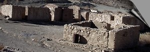
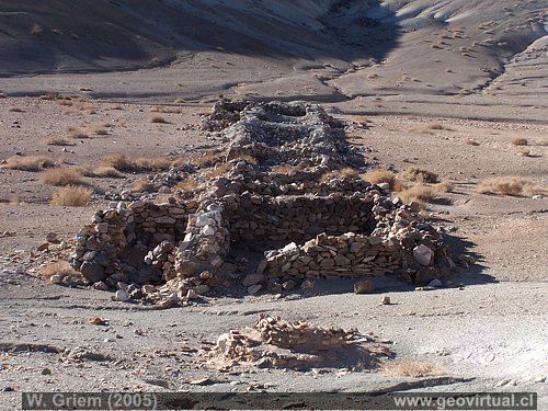
Pic 300 pueblo
Village (ruins)
The ruins of the village of Lomas Bayas are clearly visible. Rectangular shaped natural rock walls....
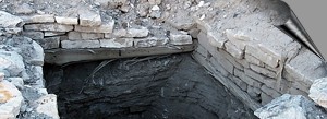
Pic Minas Lomas Bayas
Mines
The mines of Lomas Bayas still show the importance of the mining district in the vicinity of Los Loros.
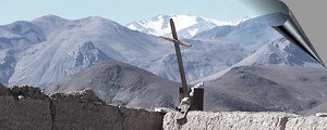
Pic cementerio Lomas Bayas
Cemetery
A cemetery with the best view of the Atacama Region - there are indeed two cemeteries. . . .
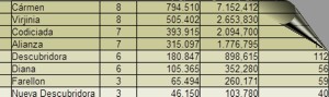
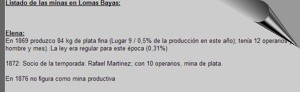
Pic Estadistica Lomas Bayas
statistics, data

Pic listado Lomas Bayas
List of mines
A listing of all historic mines with historical production information and owners . . .

Pic Textos historicos
Historical texts
San Roman 1894

Atacama black and white

next page in geovirtual

Los Loros en Atacama, Chile Copiapo en Atacama - Chile Tierra Amarilla en Atacama - Chile Quebrada Carrizalillo en Atacama - Chile Chañarcillo en Atacama - Chile Cerro Blanco en Atacama - Chile Quebrada garin en Atacama - Chile Carta: Ubicación de Lomas Bayas
Map of the Lomas Bayas area, Atacama (Chile)


Lomas Bayas - Minas y edificios (Región Atacama, Chile)

Ruins of Lomas Bayas in the Atacama Desert. Kodak14.251) -
Foto en grande


Any new publication not authorized by the authors is expressly prohibited. This applies in particular to electronic publications:  Usage guidelines.
If you have old photos or other (historical) material of the Atacama region, we would be very pleased to implement this in our pages: Contact

previous page of geovirtual
History of Atacama Mining - Content Atacama Region
History of Atacama
next page in geovirtual
silver line

www.geovirtual2.cl
Geology (Spanish)
Apuntes
Apuntes Geología General
Apuntes Geología Estructural
Apuntes Depósitos Minerales
Apuntes Exploraciones Mineras
Geological periods
Literature and Citation
Geological index (spanish)
Virtual museum
Virtual Museum: First page
Geological excursion
Some Minerals
History of Geosciences
Mining in historical literature
Fossils in historical literature
Historical authors mining and geology
Geological index (spanish)
---
Images of Chile and Atacama
---
The Coquimbo Region, Chile
The Coquimbo Region
History of the Coquimbo Region
Railroad history of Coquimbo
Names and places
---
Images from Chile
Atacama Region, Chile
Journey to Atacama
Atacama sightseeing places
History of Atacama
Mining history of Atacama
Geology of Atacama, Chile
The railroad history of Atacama
Flora Atacama
Animals of the Atacama Desert
Virtual viewpoint Atacama
Atacama en b/n
Road - maps /
Morphologic 3-dimensions
Climate history of Atacama
Books & Collection of Books
List of names and places of Atacama
sitemap - list of all files  - schematic content - Information site geovirtual.cl

www.geovirtual2.cl   / Virtual Museum: First page / History of Atacama / Mining history of Atacama
Mining history of Atacama, Chile
© Dr. Wolfgang Griem, Chile - all rights reserved  (Mail a Wolfgang Griem Uso de las páginas de geovirtual.cl y geovirtual2.cl)
Published (spanish): 30. 07.2007; Updated: 15.10.2017, 14.1.2018, 28.02.2021
Mail a Wolfgang GriemMail and contact
Ver el perfil de Wolfgang Griem en LinkedInSee perfil Wolfgang Griem
All rights reserved
Any new publication not authorized by the authors is expressly prohibited. This applies in particular to electronic publications: Usage guidelines
© Wolfgang Griem (2005, 2009) - Todos los derechos reservados - alle Rechte vorbehalten - all rights reserved
valido W3C
validated 28.2.2021
HTML/5- R