Page content:
Text introduction
Railroad lines
Historical Records
Historical Plans
Railroad cars and locomotives
Stations
- - -
Page +
Historic Railroad Network in the Atacama
Region, Chile
Looking at the current reality, it is almost impossible to imagine that
in this almost unpopulated desert there was a network of railways of
considerable dimensions. Lines were extended for industrial purposes -
especially to meet the needs of companies involved in mining. In the
early years…
more
Introduction railroads of Atacama
Introduction railroads and Map
Gauges and tracks
Interactive map with specific places
Large map and information
List
Complete list of all railway lines in Atacama, Chile


Tracks and Lines
Pan de Azúcar- Bombas - Carrizalillo
Chañaral - Mina Potrerillos y Las Animas
Caldera - Mina El Algarrobo
Copiapó - Caldera - Cerro Imán
Copiapó
Copiapó - Los Loros
y Chañarcillo
Carrizal Bajo - Yerbas Buenas - Jarilla
Vallenar
- Pedro León Gallo
Huasco,
Intro Huasco
Railroads of Coquimbo and Valparaíso Region
- - -|
Introduction: The railway history of the
Atacama region and Northern Chile .
According to today's standards, it is hardly imaginable how a network of
railway lines could have existed in this extremely depopulated desert.
In general, this network was quite impressive, but it was mainly
industrial railways. Many of the tracks were initially driven with pure
horsepower and then converted to steam quite quickly. The British
industrial dominance in the years around 1850 led to a solid extension
of the first railway lines, with a track gauge of 1435 mm known to us,
the common European standard. It must be noted that a profitable mining
industry at that time (as it is today) could only be operated with an
efficient way of transport. In the years from 1850 to 1930 this only
applied to the railway. Horses and carriages could not guarantee a
reliable and cost-effective ore transport. The railway lines, which were
not connected to each other until the construction of the north-south
line around 1914, had a considerable extension. Unfortunately, a large
number of different track gauges were used in the end. Passenger
transport was extremely important for the demographic and socio-economic
development of the Atacama region, but often not a good business for the
railway companies. In addition, the dynamics of the mining industry
(changes in prices, depletion of deposits, etc.) caused many expensive
routes to soon lead uselessly into "nowhere". Villages were founded and
after a few decades they disappeared again. Soon it turned out that many
routes were no longer enough to cover the needs of industry and the
population. With the construction of asphalted roads and the
introduction of some scheduled bus connections or the provision of
lorries, a competition was born that could not be denied. Passenger
traffic was quickly transferred to the roads, and freight traffic soon
followed. The lines were shut down for several years and were finally
dismantled. The routes of Chañarcillo, Puquios, Jarilla, to name but a
few, disappeared forever. Today (2016) this tendency continues
(unfortunately). Only the routes Mina Colorado - Vallenar - Huasco and
Chañaral - Potrerillos are still active. The tracks around Copiapó, Inca
de Oro, Paipote etc. still exist, but the last curtain has already
fallen. Not only does this mean that an investment worth millions from
earlier times will vanish forever - a piece of industrial history will
also disappear. In these pages, this part of the story is to be
recalled. Old texts, plans and current views should reflect a little bit
this, perhaps most impressive form of industrial influence on nature.
The historical travel reports - especially about rail journeys - give
the blurred perceptions a current reference. It should be noted that
the Spanish pages are a little bit more extensive than the ones written
in English and thus provide much more information.
|
Start of the route Atacama Railways
![]()
also:
Railways of Coquimbo and Valparaiso
![]()
Historical Records of the Atacama Railroad
Text
Paul Treutler Trip to Copiapo by train
Treutler: Railroad accident in 1853
Burmeister: Pabellón - Copiapó
Burmeister: Copiapó - Caldera
Philippi: Trip Caldera - Copiapó
Tornero and railway of Atacama
Bertrand Trans-Andean Project (1885)
Espinoza: Trans-Andean Project Peña Negra
Kunz (1890): Railroad of Copiapó
Kunz, 1890: Trans-Andean Project
Kunz, 1890: Trayecto Carrizal - Co. Blanco
Figures
Railway station of Copiapó (Paul Treutler)
Drawing of the train in Carrizal Bajo
Ochsenius, 1884: Railroads of Atacama
Bowman, 1913: Train at Monte Amargo
Bowman, 1913: Locomotive Matías Cousiño
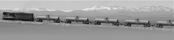
Platt, 1930: Train with people, Chañaral
1957: Vallenar Bridge
![]()
Maps related to the Atacama railways
Schematic map of current and historical routes
Railroad Map Copiapó (1882)
Railroad
map by Reclus (1895)
Railroad lines Copiapó (Espinoza, 1895)
Map railroads Atacama 1903
Map Inca a Chulo (1910)
Map Atacama 1914: Marín
Map 1928: Handbook
Map: 1943 - Guía Veraneante
Map Railroads 1943, Vassallo
Map 1947 - Guía Veraneante
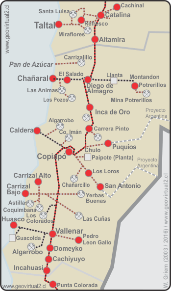
Map of the railway lines in the Atacama Region
The trails and stations
The routes in detail
List of railway stations
Complete list of all lines in Atacama
Longitudinal railway
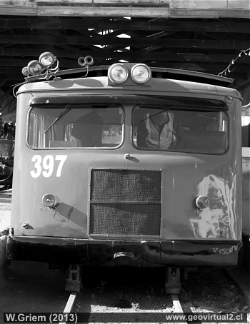
Locomotives and wagons
The Copiapo Locomotive
Machines for mining
Convoy en J. Pérez
Train downhill in Montandon
Train near Carrera Pinto (1989)
Train near Algarrobal
Pan-American Crossing Train
Wagons at Diego
Train at Diego station 1985
Wagons at
Copiapó (1) (2)
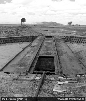
Railway stations
Taltal,
Refresco,
Ovalo
Catalina,
Severin
San Juan
Altamira
Joaquín Pérez
Pedro Montt
Chañaral
El Salado
Diego de Almagro
Inca de Oro
Carrera Pinto, Juan
Godoy,
Chulo
Trans-Andean projects (never carried out)
Copiapó
Caldera
Toledo
Chañarcillo - Juan Godoy
Carrizal
Bajo,
Canto del Agua
Carrizal Alto
Punta de Díaz,
Yerbas Buenas
Vallenar
- Pedro León Gallo
Vallenar
Domeyko
Chañar
Incahuasi
Punta Colorada
- - -
Map of railroad lines in the Atacama Region
Chile's first locomotive: La Copiapó - Currently at the Universidad de Atacama.
Railroads of Coquimbo and Valparaíso Region
Literature about railroads Atacama
A NEW BOOK! - Aviso de interés para los amantes
de los trenes:
El Maravilloso Viaje del Longino, de Julio Ortega Ilabaca. - Universidad
Católica Silva Henríquez, 2011.
ISBN: 978.956.345.407-9
más informaciones email: longino2011@gmail.com
Railways in Atacama
Railways of Valparaíso and Coquimbo
Atacama virtual
Tourist interest
www.geovirtual-(english)
Contenido - esquema
Virtual Museum Entrance
The Atacama Region
Virtual viewpoint Atacama
The Atacama desert
Atacama in black and white
Maps of Atacama
Rutas de Atacama
Pan-American highay at Atacama
Distancias en Atacama
Geology in photos
Animals of the Atacama Desert
Flora del desierto de Atacama
Climate of the Atacama Region
History
of Atacama
Mining in Atacama
►
Railways of Atacama
Airfields in Atacama
Historic maps of the Atacama Region, Chile
Atacama en 3D
Bibliografía /
Enlaces Atacama
►
Content railway Atacama
Intro 1: General
information
Intro 2: Trayectos y trochas
Intro 3: Schematic map
Intro 4: Line map
List of all lines
Longitudinal Atacama
Longitudinal Coquimbo
Registros históricos
Tourism
Journey to Atacama
Atacama sightseeing places
History
of Atacama
La Panamericana en Atacama
Others
Timeline Atacama
Mining history of Atacama
The railroad history of Atacama
Flora Atacama
Animals of the Atacama Desert
Geology in photos
Climate of the Atacama Region
The Atacama desert
Virtual viewpoint Atacama
Aeródromos en Atacama
Railroad pages
Introducción FFCC de Atacama
Mapa de líneas históricas en Atacama
Mapa con enlaces a sectores
Contenido de los trayectos en detalle
Trayecto longitudinal en Atacama
Línea Copiapó - Caldera
Trayecto Copiapó - Diego / Puquios
Línea Copiapó / Loros
Chañarcillo
Red de Carrizal Alto/Bajo (Región de Atacama)
Huasco - Vallenar
Proyectos trasandinos
Copiapó - Vallenar
Chañaral - Mina Potrerillos y Animas
Trayecto Bombas - Carrizalillo
listado general de estaciones
Estación Copiapó (Región Atacama)
Estación Caldera (Región de Atacama)
Estación Toledo en Atacama
Estación Inca de Oro (Atacama)
Estación Carrera Pint0 (Atacama)
Est. Diego de Almagro en Atacama
Estación Carrizal Bajo (Atacama)
Estación Juan Godoy (Región de Atacama)
Estación Punta de Díaz
Paul Treutler Viaje a Copiapó
Treutler: Accidente ferroviario 1853
Burmeister: Pabellón - Copiapó
Burmeister: Copiapó - Caldera
Philippi: Viaje Caldera - Copiapó
Bertrand Proyecto Trasandino (1885)
Espinoza: Trasandino Peña Negra
Kunz (1890): Ferrocarril de Copiapó
Kunz, 1890: Proyecto trasandino
Kunz, 1890: Carrizal - Co. Blanco
Plano esquemático de los trayectos
Mapa de Sayago 1882 Ferrocarriles
Red ferroviario según Reclus (1895)
FFCC de Copiapó (Espinoza, 1895)
Mapa Espinoza (1895)
Listado completo de todas las líneas