Atacama desert

www.geovirtual2.cl

Salt Flats and Lagoons in the Atacama Desert, Chile

Pedernales salt flat and Doña Ines

Viewpoint Atacama

W. Griem, 2005 - 2021

Pedernales salt flat and Doña Ines, Atacama desert, Chile

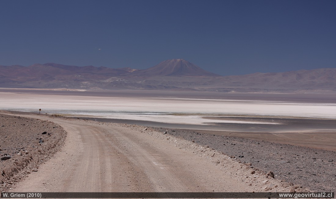
Photo: Salar de Pedernales (around 3350 meters high) - panoramic view from the west bank. In the background you can see Doña Inés Hill (height 5075 meters) in about 30 kilometers distance. (CaXSi639; W. Griem 2010)

Description:
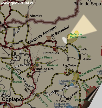
Location: The Pedernales salt lake is located east of El Salvador or Diego de Alamagro.
Next town: El Salvador (60 km), Diego de Almagro (103 km)
Petrol: El Salvador (60 km), Diego de Almagro (103 km)
The place: One of the most charming landscapes, the almost dimensionless salt lake and the volcanoes on the other bank. Road: The main road is salted and in good condition, the shore road around the Salar is gravelled, and quite narrow - besides, almost without traffic, if you want to drive further than to the Boraxmine you should drive with 2 vehicles. In any case 4X4 (SUV, Jeep or Pickup).
UTM: E475.089 / N70.89.264 - Height: 3405 m. (picture).
more information about Salar de Pedernales sector

Information Photo: Canon Camera XSi
Lens: 50mm + pol. | Focal length: 50mm (81,2/35mm) | Time: 1:200 | ISO100
F: f/7.1 | Original size: 4272 x 2848 | Date: 2010/03/06/13:46hrs.

Map of the area Pedernales atAtacama desert, Chile


Any new publication not authorized by the authors is expressly prohibited. This applies in particular to electronic publications:  Usage guidelines.

previous page of geovirtual, Atacama
Viewpoint content - Content Atacama Region
List of names and places of Atacama
next page in geovirtual, Atacama
line silver en www.geovirtual2.cl

www.geovirtual2.cl
Geology (Spanish)
Apuntes
Apuntes Geología General
Apuntes Geología Estructural
Apuntes Depósitos Minerales
Apuntes Exploraciones Mineras
Geological periods
Literature and Citation
Geological index (spanish)
Virtual museum
Virtual Museum: First page
Geological excursion
Some Minerals
History of Geosciences
Mining in historical literature
Fossils in historical literature
Historical authors mining and geology
Geological index (spanish)
---
Images of Chile and Atacama
---
The Coquimbo Region, Chile
The Coquimbo Region
History of the Coquimbo Region
Railroad history of Coquimbo
Names and places
---
Images from Chile
Atacama Region, Chile
Journey to Atacama
Atacama sightseeing places
History of Atacama
Mining history of Atacama
Geology of Atacama, Chile
The railroad history of Atacama
Flora Atacama
Animals of the Atacama Desert
Virtual viewpoint Atacama
Atacama en b/n
Road - maps /
Morphologic 3-dimensions
Climate history of Atacama
Books & Collection of Books
List of names and places of Atacama
sitemap - list of all files  - schematic content - Information site geovirtual.cl

www.geovirtual2.cl (english) / Virtual Museum / Atacama Region / Viewpoint Atacama
Virtual Museum of Atacama desert and Atacama Region, Chile
© Dr. Wolfgang Griem, Chile - all rights reserved  (Mail a Wolfgang Griem Uso de las páginas de geovirtual.cl y geovirtual2.cl)
Published: 18.11.2017, Updated: 18.11.2017, 27.02.2021
Mail a Wolfgang GriemMail and contact
Ver el perfil de Wolfgang Griem en LinkedInSee perfil Wolfgang Griem
All rights reserved
Any new publication not authorized by the authors is expressly prohibited. This applies in particular to electronic publications: Usage guidelines
© Wolfgang Griem (2005, 2009) - Todos los derechos reservados - alle Rechte vorbehalten - all rights reserved
valido W3C
validated 27.02.2021
HTML/5- R