Content
Chañarcillo today
Introduction
Geology
Historical Records
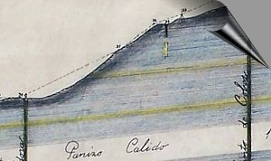
District Map
Literature
---
page +
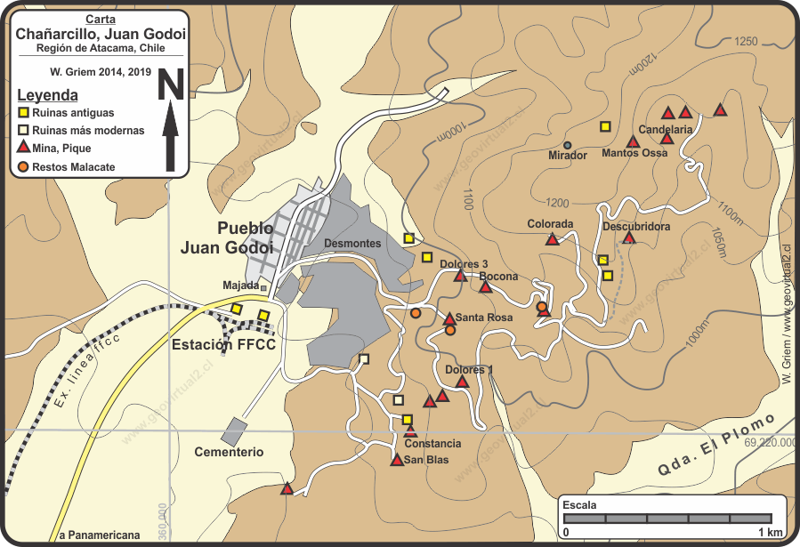
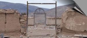
The ruins of Chañarcillo and Juan Godoi
today - an tourist excursion
The ruins of the Juan Godoi village of Chañarcillo mines still show the
magnitude of the mining district. . . .
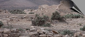
The mines today
Descubridora -
Mina Dolores 1 -
Dolores 3 -
La
Colorada -
Bocona
-
Santa Rosa -
San Francisco
-
Constancia. From the famous mines of Chañarcillo,
almost nothing remained visible from the outside, an attempt to plot something
. . .
Geology of the Chañarcillo mines (San Roman, 1894)
Historical descriptions of the mines
El manto:
El manto en general
Manto de los Bolados
Manto de los Cobos
Las Guías
Mines of the Colorado or San Francisco lode
Geology of the vein Colorada Domeyko (1846)
Valenciana Cobriza
Profile Valenciana (Moesta)
Esperanza
Colorada
Desempeño
Bocona
San José y San Francisco
Introduction to the
Chañarcillo sector
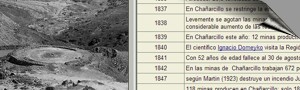
Chañarcillo, one of the most important silver mining districts in the world.
The module of Chañarcillo del Museo Virtual tries to illuminate the history
of this famous silver deposit and the mythical village of Juan Godoi (today
Juan Godoy). Between 1832 and 1890, then for a period of about 58 years,
this place catapulted the Atacama region to the leading edge of world mining.
The Atacama Region joined industrialization and globalization.
The pages of the history (Here)
give a small chronological list of the most important facts of the Chañarcillo
area.
The "tourist pages" (Here)
show the sector as it is now and show the striking environment between the
desert with the remains of walls and debris and a brilliant history, of
incalculable riches
For more information, especially more detailed information, a list of all
mines with active links to production data or geological data is included
in "Pertenencias".
There are some historical texts, for example a text on the apires and barreteros
of Chañarcillo de
Gilliss, 1855, an interesting document on life in mines of the time
1855.
As we know, industrialization and technology have shown an unimaginable
increase over the last 150 years. For example, the amount of silver produced
worldwide in 1850, today Chile produces in a single year - Chile is only
number 6 in the current ranking of silver production (2003): Chañarcillo,
with its production rate of 1869, today would contribute only 3.4% of Chilean
silver production extracted throughout the year.
Cemetery
The cemetery of Juan Godoi
Timeline of the history of Juan Godoi and
Chañarcillo
Statistics
general -
1869 -
1876
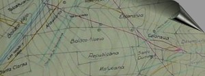
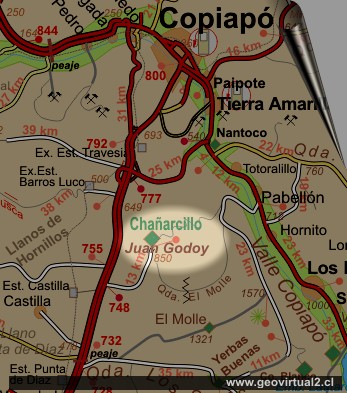
Maps of Chañarcillo
Map of Domeyko (1903)
Map of veins: Moesta
Map of mining rights (1862)
Map Dolores 3ra
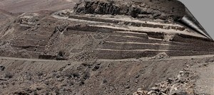
Perfil geológico
Perfil Domeyko
Perfil de la mina Candelaria
3 dimensional view of the sector
Geological Quotes
"Chañarcillo"
Informative Chart
Place: Chañarcillo, Juan Godoi or Juan Godoy
Copiapó Communa, Atacama Region
UTM Location: E360.490 / N69.22.780
Height: 880 m
Location: 50 km to the S (straight line) of Copiapó.
Road distance: 73 kms from Copiapó
Status: Abandoned
Mineralization: Ag (silver) in veins and layers.
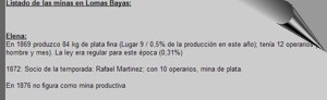
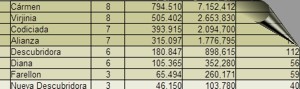
Listing of all historic mines with historical production
A listing of all historic mines with
historical production information and owners . . .
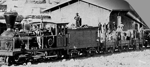
The railway of Juan Godoi and
Chañarcillo
Line to Chañarcillo
Historical Records
General historical texts
Domeyko
in Chañarcillo: Historia y cuentos
Descripcion de KUNZ (1890):
Juan Godoi, historia, situación en 1890
The miners of Chañarcillo (Gilliss, 1855)
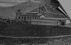
Historical images:
Picture of the mines (por A. Pissis)
Dolores
1 mine
Mining Atacama
Atacama virtual
Tourist interest
Old mining districts of
Atacama:
Mining and Mines
Introduction Atacama mining
Mining from 1830 to 1920
List of mine districts
►
Chañarcillo
Tres Puntas
Cerro Blanco
Lomas Bayas district
Agua Amarga
Inca de Oro district
Puquios - Carrera Pinto
Cachiyuyo de Llampos district
más lugares ...
Near
Camino histórico
Panamericana
History of mining
Introducing epoch 1830-1920
Technical innovations
Scientific innovations
Social conscience
Educational impulse
Mine safety
Globalization
Tourist information
Atacama
Travel instructions
Behavior in the desert
Specific
terms
The Andes mountains
Atacama desert
Others
Railroad history of Atacama
Mining history of Atacama
List of mine districts
History of Atacama
Flora Atacama
Fauna Atacama
Geología Atacama
Climate of the Atacama Region
Atacama desert
Beaches and coast of Atacama
The Andes mountains
Rutas de Atacama
Carretera Panamericana
Aeródromos en Atacama
Módulos
Atacama b/n
Virtual viewpoint Atacama