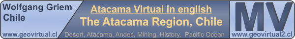
The Ojos del Salado Volcano in the Atacama Desert, Chile
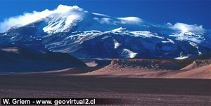
Adobe Wall in the Atacama Desert, Chile
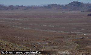
Llano in the Atacama Desert, Chile
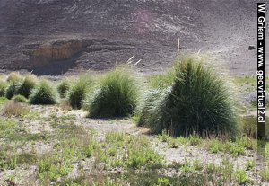
Vega or oasis in the Atacama Desert, Chile
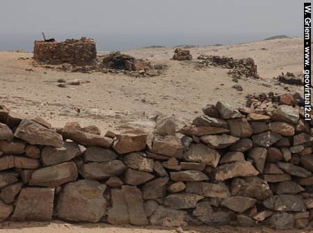
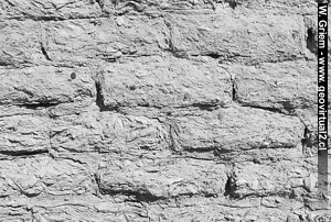
Pircas: Walls in the Atacama Desert
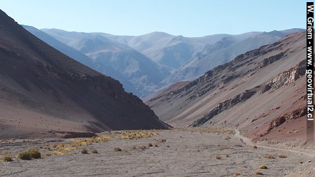
Photo: The Atacama Desert in Chile near Inca de Oro.
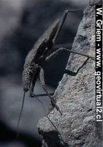
The Vinchuca in the Atacama Desert, Chile
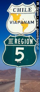
Panamericana Highway
Specific terms of Atacama
General information:
The Atacama region is located in the "Little North" of Chile. The
capital is Copiapó, about 800 km north of Santiago. The climate of the
region is consistently arid/semiarid with some nuances between the
southern and northern areas. The region stretches from the Pacific Ocean
to the main ridge of the Andes, which has in this area between 4100 m to
6842 meters. The area north of Copiapó can be called the "real" desert.
In general, the Atacama region has a good infrastructure. The roads are
quite well developed (due to the low population density) - although not
all parts of Atacama can be reached on asphalted roads.
This website is intended to present the tourist value of the Atacama
region and to explain the historical background - especially the
historical development of industry and mining. Of course, the landscape,
culture and current life must not be neglected. Finally, a few
frequently used terms should be explained in more detail. The Spanish
language was often retained in the pages, especially for proper names.
Collection of some Spanish and
Atacama specific terms:
Adobe: An unfired brick mostly made with a mixture of
clay and straw chaff, often used for building walls and houses. The
Adobe constructions are not water-resistant and have inferior seismic
properties in the most frequent earthquakes. Also, the not harmless
Vinchuca bugs can nest there.
Examples of Adobe buildings: Ruins of
Puquios, houses in Copiapó
Camino: Path, Street
Carretera: Asphalted
main road (Pan-Americana)
Chusca: It is fine dust
(Silt) that usually accumulates in some places due to the accumulation
of wind and later flooding and leaves a considerable dust trail when
driving through with the car, which remains in the air after many
minutes. Chusca often fills potholes, which makes driving through them
at high speeds even dangerous. If you encounter areas with Chusca, close
the windows in the car immediately and change the fan to internal
circulation - otherwise, the passengers can look "powdered."
Kollas or Collas: Ethnic
group that lived in large parts of the region before the Spanish
colonization. Today, many communities live in the oases of the
pre-cordillera. The Collas have their language, customs, and culture.
Many towns and mountain names have their origins in the language of the
Collas. Examples: Puquios, Chanchoquin, Chuquicamata etc.
Cordillera, Cordillere:
Means mountain range. In the Chilean Andes, a distinction is generally
made between the coastal cordillera, the pre-cordillera and the main
cordillera. The word "Cordillera" is often equated with the main
cordillera.
Lama - Guanaco . Vikuña:
Two of the four Lama species can be found in the region of Atacama: the
Guanakos (in Spanish Guanaco) and the Vicunjas (in Spanish: Vicuñas).
See: Vikunjas and Guanako.
Llano: Coating
surface mostly high plateau. Due to the lack of erosion processes in the
desert, there are large, almost flat plateaus. For example, the Llano de
Varas.
Portezuelo: Mountain
pass
Pircas: Like walls,
simple stone houses.
Pirquineros: Miners
working in small groups in simple mines.
Pique: (vertical)
shaft of a mine.
Quebrada: A dry
valley, which got its appearance due to spontaneous heavy rains in the
local desert climate. Often the abbreviation Qda. is used. In normal
(dry) times, no water flows in these valleys. An example here: Quebrada
Carrizalillo.
Salar: Salt flats. In
the Atacama region, some salt accumulations are located in draining
basins between the pre- and main cordillera. Example Salar de Pedernales
- The Pedernales salt flat:
Salar de Pedernales
Vega: Small oasis -
mostly situated in the mountains.
Vinchuca: A predatory
bug is native to many parts of South America. One of the few dangerous
animals in Atacama. The Vinchuca is the carrier of Chagas disease.
See Vinchuca
Places of interest
Information about Atacama
Atacama
Travel instructions
Behavior in the desert
●
Specific terms
The Andes mountains (I)
The Andes mountains (II)
Atacama desert (1)
Atacama desert (2)
Rains in the Atacama desert
Flowering desert (1)
Flowering desert (2)
Flowering desert (3)
Snow in the Atacama desert (1)
Snow in the Atacama desert (2)
Virtual viewpoint Atacama
Atacama black and white
Road maps of Atacama
History,
Mining, Atacama
Climate of the Atacama Region
Mining in Atacama
The railroad history of Atacama
Atacama landscape
The Atacama desert
Flowering desert
Beaches of Atacama
Las Dunas
de Atacama
Desert & Atacama
Journey to Atacama
Rutas en Atacama
Pan Americana
Distances within Atacama
Road maps of Atacama
Atacama Litarature & Books
Links, enlaces Atacama
Imágenes 3-dimensionales