Francisco San Román
Content
Pictures
Annotations
Text
---
page +
Francisco San Román
1894: page 209 - 215
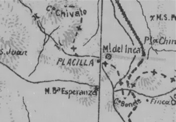
Map from Orrego (1903)
The text of Francisco San Román is a good, early, geological description of the mining district of Tres Puntas. he highlights the district's potential, lack of research and likelihood of finding more resources. Its text on the one hand is well scientific, on the other hand it does not strictly maintain its scientific style.
- 1 -
As early as 1894, the word propylic was used - for an altered rock.
- 2 -
San Roman compares the desert landscape with glacial - post-glacial
formations; the soft morphology is really a similarity but it should be
noted that there are profound differences between the two types of
landscape.
- 3 -
Mainly Gryphaea Arcuata and Gryphaea Darwinii see photo see historical
paintings
see photo
see historical pictures
- 4 -
San Roman specifies in this paragraph the absence of scientific
research, especially the lack of plans and models of the mines of Tres
Puntas.
Literature: Tres Puntas
Extracts from the book "Industrial and Historical Review of Mining and Metallurgy in Chile" by Francisco San Roman from 1894. A description of the geology and mining district of Tres Puntas.
Tres Puntas:
Tres Puntas: The calcareous strata continue their invariable
course to the NE, leaving traces of their passage in small islets or
rockshells attached to the hills or sticking out under the alluvium of
the desert until they collide with the southern slopes of two small
cords that cross each other in the longitudinal plain and that received
from the miners the names of "El Volcán” and “Tres Puntas”.
Object of real or dreamt discoveries, it is already known how he finally
came to find those new emporiums of silver. There is no characteristic
formation in powerful successions of strata that can be seen in the
distance with its smooth and continuous silhouettes, its steep cuts and
bands, waving in the heights like wide strips of various colors. In the
Chimbero mine it is just a protuberance that appears between the shades
of dark red and violated from the earthy sandstones of an ancient, but
undetermined time.
A short extension of diorite appears in the south and against it the
calcareous layers impregnated with silver ore that constitute that
powerful hatchery crash and vanish. Eurythic rocks of different shades
occupy the rest of the formation. Extending from there the view over the
plain of the arid desert, the attention is fixed on a height that boasts
and stands out as an advanced messenger to meet the traveller that goes
there from all directions of the south. It is "El Bonete" hill with its
dark colors and volcanic appearance, its rough flanks and its rounded
summit in the shape that indicates its name.
Curious detail is this fact that we are already left pointed out in
Chañarcillo with the volcanic cone of Bandurrias, as a witness of the
inner actions of the planet and vigilant of the riches enclosed there;
reproduced also in El Bonete de Tres Puntas; repeated later in Caracoles
to serve as a guide by the loneliness of that vast wasteland in the same
characteristic form in the height that the first explorers called "El
Centinela".
From Chimbero, passing between El Volcán and El Bonete, we arrive a few
kilometres away from the terrain where the Tres Puntas mines are
located, on limestone formation in a undulated plain. In the center, a
large stream of a porphyry diorite, a beautiful rock that can be
equivalent to Nevada's propylite (1) in the United States, forms a
powerful dike from whose outcrops to the surface have been detached
pieces that, rounded by the action of time and scattered on the surface,
offer the appearance of a field planted with errant blocks that would
have been deposited there by the travelling ice of the time (2).
The fantasy of the prospectors (cateadores), impressed with that strange
aspect, gave birth in some of them to the idea of some relation of those
blocks with the silver hatcheries and they took it into account among
their signs indicating wealth. On the slopes of Tres Puntas Hill are the
benches of andesite and trachytic tuffs in variegated relation to the
calcareous strata, among which stands out a black layer that is a true
conglomerate of grifaeas (3) characteristics of the lees blocked by
cement impregnated with fossil bitumen that emits an unpleasant smell
when hit with the hammer. This fossiliferous layer constitutes a
geological horizon that also manifests itself at the foot of the
Chañarcillo hill; and in the San Carlos mine, in the Juncal al Carrizo
mountain range, it forms one of the boxes of the silver vein.
As in "Ladrillos" can be said of Chimbero, with greater reason, and also
of Tres Puntas, that the transition from the upper region of the
chlorinated species of silver to that of sulphides, has been even faster
and much less extensive depth than in Chañarcillo.
The "Buena Esperanza" mine and annexed belongings of the Chimbero
resulted from the discovery of a crestón of pure silver chloride
accompanied by limestone gangs, iron oxides and shallow copper
indications of the green colored species.
The discoverers made open-pit and soon discovered that it was not the
existence of a single vein but a series of layers or a series of
grained veins that intersected with each other, enriching itself and
distributing mineral currents among successive mantles until
considerable distance from the line of intersection, a distance that in
parts has exceeded one hundred meters.
No reasoned study or illustrative plans of the geognostic
characteristics of that powerful and interesting hatchery have left the
administrators of that mine who were so abundant in resources and money
without limits to have developed a system of underground explorations
that would have been so productive in the days of the current decline.
English, French and Germans followed one another there, but none of them
have been able to obtain traces that guided us with the criterion of the
investigation in that underground labyrinth of deposits in all forms and
of labors followed to all the directions of the nautical rose (4).
Eurythic rocks intervene there with calcareous strata in introductory
layers, but distributed in an order or according to some mineral content
that no one has been careful to find out. In all times there was that
sense of mystery, secret assumptions and cloaked saints that the
vulgarity and tactical leguleya in the ventilation of lawsuits always
opposed the study and general knowledge of the conditions and
singularities of each mining seat, which so teaching experience and so
useful works of information and consultation could have left us.
In little more than a hundred meters deep, the nomenclature of the
mantle of AAs, BBs, and MMs, in the series of metalliferous layers, had
exhausted the alphabet of the languages, distinguishing itself with the
name of Manto San Juan de Dios, which more than millions pushed in
circulation of Chile's public fortune.
At such shallow depth, nothing was known of the future of that opulent
deposit: the vein of Buena Esperanza, in its regular formation and
ordinary dimensions of striking and power, was not the object of deep
research after the interposition of a stone horse separated it into two
groups filled only with the generous carbonate of lime, but without
costing benefits; nor were explorations
followed in the horizontal on it or on the the other estructutres as
link between the two points, the limestone formation is developed
on the hill of the Volcano, in the mine of the same name, and on the
other hand in San Pedro Nolasco, in the Republican and in the rich
guides of Barcelonesa, with the inseparable green eruptive rock and the
metamorphic garnets of Chañarcillo. In Tres Puntas they open the veins
on the terrain barely undulating or on the surface, but the stratified
formation appears solid in depth.
The eruptive rocks have produced more disturbing and profound accidents
there than in Chañarcillo, dragging the veins along their course and
dislocating them strongly. Thus, the vein of the "Juana","Salvadora"
and "Al fin Hallada" rises recumbent and sterile against the eastern
wall of the dioritic dike; it is enriched when crossing the calcareous
stratified formation changing at the same time of direction, it is
joined with other filons or veins of calcium carbonate or barium sulfate
that enrich it even more, and thus, from one unusual situation to
another, the angles that form in its course the shape of a zig-zag..
The thickness of the stratified formation does not seem considerable
there, but the works in the Al Fin Hallada sustained the extraordinary
production of native silver and pure minerals while it lasted there,
without interruption up to 130 vertical meters and in a horizontal
stretch that embraced up to 150 meters.
Continue with good expectations of continuity for 170 meters more, at
the depths of which a dyke or set of dykes interposed within which, the
vein disappears, had no continuation, abandoning the explorations until
today and remaining so to solve one of the underground problems most
caressed by the faith and constancy of the miners of Copiapo.
Numerous other mines of Tres Puntas, such as "Victoria","Lautaro","San
Rafael" and others, all of them rich within the first depths, and carved
on veins of different courses and with more or less analogous
characters, have also been abandoned without having resolved the doubts
of the continuity of their benefits in new sectors. Deposits of another
nature, in pits, such as the "Gallofa", and in successions of mantles,
such as the "Luz del Pilar", have not been the object of recognitions
that could discover new and productive areas of exploitation.
Ascending at a certain height by the slopes of the cordon of the Tres
Puntas, was found the mantle that carried the name of "San José",
located at the foot of a dioritic hill and which was studied especially
by the distinguished geologist engineer Don Lorenzo Sundt during our
explorations of the desert of Atacama. It describes there a dislocation
of the ground that causes a slippage of hostrock of the mineral layer in
a vertical of 40 to 50 meters, producing the consequent discontinuity in
the stratification planes and attributes the appearance of the rich
native silver condensations that took place there to the interposition
of the diorite, within whose rock the sterility of the seams is general.
Los textos originales fueron digitalizados, transformados
a ASCII redactados por Dr. Wolfgang Griem.
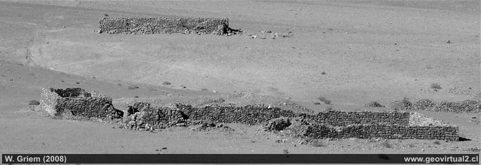
Ruins of Tres Puntas in the Atacama Region in 2008
Mining in historical pictures
Mining Atacama
History of Atacama

Content Mining
List of the districts
Mining
between 1830 to 1920
Chañarcillo
Tres Puntas
Pueblo,
Cementerio
Buena Esperanza,
Cobriza
Cronología de Tres Puntas
Treutler: Vida Tres Puntas
Treutler: Bar de Tres Puntas
Treutler: Interior Salvadora
Treutler: Situación laboral
Treutler: Minería Tres Puntas
Treutler: Terremoto Tres Puntas
Treutler: Accidente Tres Puntas
Simonin v/s Treutler
►
San Román: geology Tres Puntas
Carta minero de Cornwall
Philippi en Tres Puntas
Philippi: Descripción Tres Puntas
Philippi: Historia Tres Puntas
Cartas sector Tres Puntas
Listado minas de Tres Puntas
Estadísticas de Tres Puntas
Cerro Blanco
Lomas Bayas
más lugares ...
Mining history of Atacama
Mining
in the years 1830-1920
List of minig districts Atacama
Chañarcillo
Tres Puntas
Carrizal Alto
Cerro Blanco
Lomas Bayas
Cabeza de Vaca
Francisco
San Román
Descripción Tres Puntas
Descripción Puquios
Carrizal Alto
Cerro Blanco y Jarilla (Bronces)Cachiyuyo
de Llampos,
Inca e Isla
Lomas Bayas
Personajes de Atacama
Literatura
Paul Treutler (1851)
Intro Treutler en Atacama
Paul Treutler en Copiapó
Paul Treutler en Caldera
Viaje en Ferrocarril por P. Treutler
Accidente ferroviario en 1853
Treutler
en Tres Puntas
en Salvadora (Tres Puntas)
accidente en Tres Puntas
carta de Atacama
Terremotos (general)
Terremoto en Tres Puntas, Atacama
TREUTLER -SIMONIN, comparación
Paul Treutler
Comparación total
Visitantes de Atacama
Listado de Visitantes
R.A. Philippi en Atacama
Paul Treutler en Atacama
Charles Darwin, Atacama (1835)
Ignacio Domeyko y Copiapó
Kunz en Copiapó
Hugo Kunz en Chañarcillo
Gilliss Mineros en Chañarcillo
Información adicional
Cronología histórica de la Región
Minería de Atacama
El Ferrocarril en Atacama
Cartas y Mapas de Atacama
Cartas históricas de Atacama
Listado de personajes de Atacama