J.M. Gilliss
Content
Pictures
Annotations
Text
---
page +
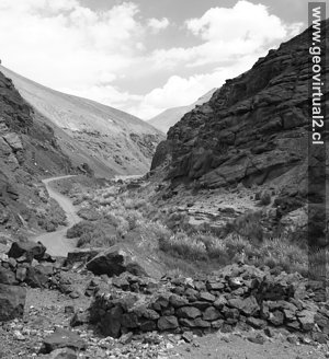
Sector Turbio, Portezuelo Cachitos
The text of J. M. Gilliss in the first pages of his report on the astronomical excursion to South America (part Chile) on the situation of the Andes in Atacama. It's the same sector where Domeyko and Burmeister moved.
- 1 -
Currently the Come Horse is not passable. The portezuelo neighboring the
Pircas Negras was enabled.
- 2 -
All authors who traveled in this sector report the impressive amount of
ruins.
Map ofGilliss
Portezuelo Pulido:
Today the Cachito was opened in the vicinity of Portezuelo Pulido.
Literature: Excursions in Atacama, Chile
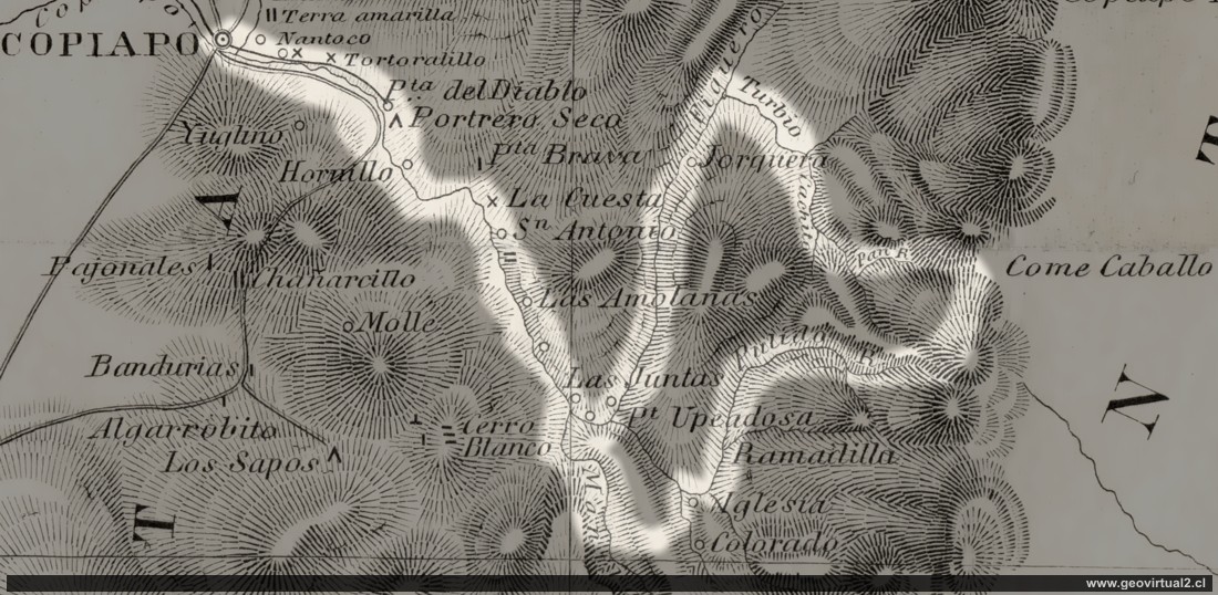
Pass COME CAVALLO. Text from Gilliss (1851) -
J.M. Gilliss, visited during the U. S. astronomical
expedition" in 1851; The Atacama Region, page. 7-9.
Text:
Paso COME
CAVALLO (hoy Come Caballo):
Gilliss at Atacama: DESCRIPTIVE GEOGRAPHY.
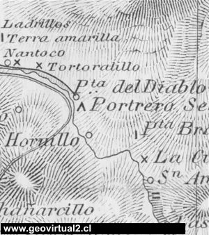
COME CAVALLO Pass.-Leaving the city of Copiapó, the road leads up the
valley of the river of the same name as far as the confluence of the
Jorquera, Pulido, and Manflas, which, from my determinations of the
geographical position of Copiapó, and the bearings and distances thence
of Prof. Domeyko, will be near latitude 27 º 56’ south, and longitude
69° 50’ west. The elevation of this confluence is somewhat less than
4,000 feet, and it is below this only that the river takes the name
Copiapó. A more detailed notice of the valley, or rather ravine, as far
as Punta del Diablo, about one half the distance to these rivers, will
be found in the narrative of a journey to the mines of Chañarcillo.
There it will be seen that only the geologist and mineralogist find
objects of interest. Reflected heat from utterly barren rocks on both
sides of a long narrow gorge; scarcely water to quench the thirst, after
hours of travel over broken and stony paths; probably not one
representative from all the animal kingdom to show that man is not the
only creature tempted to visit scenes nature has so desolated-these are
some of the characteristics not easily forgotten.
As one ascends the valley towards the confluence of the rivers, the
supply of water increases, and the soil permits occasional patches to be
brought under cultivation through its aid; indeed, Potrero grande,”
between the village of San Antonio and the junction, has become famous
in this region for its fruits and vegetables. The mind ever seeks
objects of comparison; and the few standards belonging to the vegetable
kingdom nature has vouchsafed in many thousand square leagues of
northern Chile, have doubtless their influence to enhance the charms and
products of Potrero grande; so that, when the lover of verdure arrives
there, worn out by days and weeks of travel amid sterility, as his
vision may not have rested on a leaf or stalk in all that time, he hails
the sight of fig-trees in full hearing as would the patient, long
stricken by fever, a stream of cool and limpid water. From the
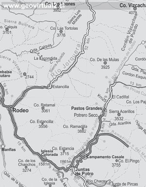
confluence of the rivers there are two paths towards the cordilleras-one
by the Jorquera, the other by the Pulido. -That by the Jorquera is the
longer, though it possesses attractions making it of sufficient interest
for one to encounter the additional fatigue, viz: a ravine, whose strata
contain an abundance of marine fossils, and, a little further up stream,
the ruins of an Indian village, probably built when the Peruvians were
masters of the country.
One house, at the southern end of the village, was much larger than the
others, the fragments of its walls proving that it must have contained
several rooms. Besides this, there are the walls of some thirty others,
from 8 to 10 feet in diameter, and about 2 feet thick. There is no
cement to any of them. As somewhat similar settlements are found at
several places in the Andes, between Copiapo and San José, it is
somewhat surprising that Indians should have chosen such inhospitable
heights for their homes, whilst there was a more genial temperature and
less aridity below.
The most numerous fossils are pectens, lying in calcareous strata, among
layers of porphyry, breccia, and stratified porphyry. South of the
Pulido, and on the same meridian as this, there is another deposite of
marine fossils even more interesting, from the greater variety of shells
exposed to sight, pectenites and terebratulae being very abundant.
In the valley of the Pulido, at an elevation of 10,000 feet, there are
ruins of another Indian village, called Pircas, now occupied only as a
preventive station against contrabandists. Freshly fallen snow was found
here early in March, and the warmly-clad guard were shivering over fires
in a locality once occupied by half-naked Indians. Somewhat higher up, a
depression in the mountains called “Portezuelo Pulido”* would indicate
that here was the highway; but, in reality, the road leads northward
into the valley of El Pan, on the river Jorquera, where
the night is usually passed in a natural cavern of the red porphyritic
breccia. This cave affords mountain travelers a commodious shelter from
storms, and there, also, they lie by during the violence of noon-day
winds, the guides invariably telling each one that, after 11 o’clock, it
is often impossible to move; therefore they must start up the final
ascent by early dawn, although the distance from the cave to the
dividing line is only two hours.
In this final stage of the journey, short as it is, one has full
opportunity to examine the last lines of stratified formation, which, as
they approximate the granites composing the most elevated ridge of the
Andes, exhibit evidences of the violent revolutions and terrific shocks
that they have experienced; as if the force which thrust these enormous
granite masses from the bosom of, the earth, had actually concentrated
its energy for the very crest of the mountains. Among the rocks which
enter into the composition of this up-borne formation, the breccias and
brecciated porphyries predominate. Their surfaces are at times black as
coal, at others of a deep crimson, again of an ashy-gray, and not
unfrequently are striped in lines of every imaginable shade.
Though there are places where the inclination is in a contrary
direction, the general dip is to the west. However, such are the
characters of the rocks, there is so great a variety and so many
modifications of species, that one must acknowledge nature has brought
together, at this last pinnacle of the system, a specimen from almost
every class composing the secondary formation of the western slope of
the Andes. At this immediate point, the summit is composed of a rounded
mass, entirely without vegetation, covered with feldspathic and
quartzose detritus, forming gentle slopes marked by moderate ravines.
Though snow was seen on the south sides of cones somewhat higher than
the portezuelo, and even in the deep ravines much lower down, none was
found in the pass 14,522 feet above the sea in the latter days of March.
There is a striking contrast in the configuration and colors of the two
sides of the Andes, as seen from the summit here. To the west there is a
complete reversal of the primary formation escarpments overturned,
stratifications distorted and interrupted, and, indeed, no two mountains
of the same constituents, form, or shade. On the other hand, eastward we
see gentle declivities, with beds of nearly horizontal and rarely
interrupted rocks, whose extremities form lines almost parallel with the
horizon; few tints, vegetable or mineral, to shade the picture, and only
a small number of conical and isolated summits, distant from the line of
the crest, by which the monotony is partially relieved. There is a
conical peak to the northward, some eight or ten leagues, which is
apparently much higher, and the guides say that it is perpetually
covered with snow; but those in the immediate vicinity of the pass do
not rise more than 300 or 400 feet above it. All beyond is terra
incognita, except to the professional mine hunter or smuggler.
*Portezuelo is a depression in chains of bills or mountains, always
selected for roads passing from one side to the other.
Los textos originales fueron digitalizados, transformados
a ASCII redactados por Dr. Wolfgang Griem.
Mapa de Gilliss 1851
History
of Atacama
Interés turístico

Intro valle Río Copiapó
Texto de Domeyko (1843)
●
Text of Gilliss (1855)
Copiapó (Km 0,0)
Tierra Amarilla (km 15,7)
Nantoco (Km
22,2)
Sector Nantoco
El Río Copiapó
-
a Cerro Blanco
Punta Brava (Km
53,7)
Los Loros (Km 62,3)
San Antonio (Km 70,1)
Smelter
Inka (Km 74,0)
Aqueduct
Amolanas (Km 82,2)
Lautaro
reservoir (Km 84,2)
Iglesia Colorada (Km 110,1)
Río Montosa (Km 115,4)
Junta de Potros (Km 118,9)
La Semilla
Pastos Grandes (Km 137,1)
Qda. Pircas Coloradas (146,1)
Port. Cachitos (Km 167,1)
Río Turbio (Km 194,5)
J.M. Gilliss
Mineros en Chañarcillo
Excursión Come Caballo (Andes)
Descripción terremoto 1851
Imagen
de Caldera
Módulo
Illustrations of Chile
Caldera (Gilliss)
Santiago, La Moneda (Gilliss)
Santiago, El palacio (Gilliss)
Santa Lucia, Santiago (Gilliss)
Laguna Aculeo (Gilliss)
Minería de Atacama
Minería entre 1830-1920
Listado distritos de Atacama
Chañarcillo
Tres Puntas
Carrizal Alto
Cerro Blanco
Lomas Bayas
Cabeza de Vaca
J.M. Gilliss
Los Mineros (Tornero 1872)
Iglesia y plaza de Copiapó
La Calle de Chañarcillo
Mina Dolores Chañarcillo (Tornero)
Cancha de la mina Dolores 1a.
Tres Puntas - Tornero
Visitantes de Atacama
Listado de Visitantes
R.A. Philippi en Atacama
Paul Treutler en Atacama
Charles Darwin, Atacama (1835)
Ignacio Domeyko y Copiapó
Kunz en Copiapó
Hugo Kunz en Chañarcillo
Gilliss Mineros en Chañarcillo
Información adicional
Cronología histórica de la Región
Minería de Atacama
El Ferrocarril en Atacama
Cartas y Mapas de Atacama
Cartas históricas de Atacama
Listado de personajes de Atacama